


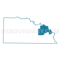
NEW LONDON Voting District, Union County, Arkansas
About
Outline

Summary
| Unique Area Identifier | 528320 |
| Name | NEW LONDON Voting District |
| County | Union County |
| State | Arkansas |
| Area (square miles) | 83.80 |
| Land Area (square miles) | 82.72 |
| Water Area (square miles) | 1.08 |
| % of Land Area | 98.71 |
| % of Water Area | 1.29 |
| Latitude of the Internal Point | 33.19207580 |
| Longtitude of the Internal Point | -92.29481340 |
Maps


Graphs
Select a template below for downloading or customizing gragh for NEW LONDON Voting District, Union County, Arkansas


Neighbors
Neighoring Voting District (by Name) Neighboring Voting District on the Map
- Eagle Lake Voting District, Bradley County, AR
- HBANKS Voting District, Union County, AR
- LAWSON Voting District, Union County, AR
- NEW UNION Voting District, Union County, AR
- STRONG COUNTRY BOX Voting District, Union County, AR
Top 10 Neighboring County Subdivision (by Population) Neighboring County Subdivision on the Map
- Lapile township, Union County, AR (2,219)
- Johnson township, Union County, AR (1,459)
- Harrison township, Union County, AR (655)
- Wilmington township, Union County, AR (604)
- River township, Bradley County, AR (131)
- Eagle township, Bradley County, AR (125)
Top 10 Neighboring Unified School District (by Population) Neighboring Unified School District on the Map
- El Dorado School District, AR (26,332)
- Strong School District, AR (3,312)
- Hermitage School District, AR (2,821)